
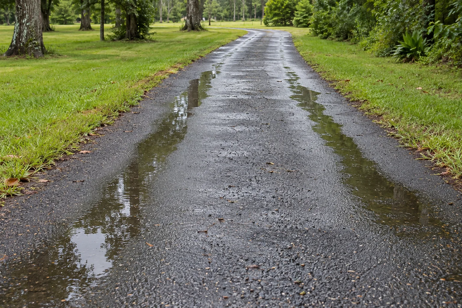
Record the depression pattern and water separately
Wheel-path ruts are longitudinal depressions along the paths vehicles use. When those depressions hold water, the owner has both a pavement-shape observation and a water-collection concern. Record both rather than assume that a single surface correction necessarily addresses the full question. The visible pattern does not establish which layer moved or why it happened.
The FHWA distress manual describes rutting as a wheel-path surface depression and includes standing water in ruts among its examples. That terminology helps name the observation, but it is not a diagnosis of the construction at your property. An evaluation may need to consider the pavement, use and surrounding conditions before the appropriate scope is selected.
Start with the location and practical effect. Describe whether the concern lies on a driveway, private access lane, parking aisle or delivery route. Note whether water remains in one path or both and whether nearby areas also collect it. A contractor can use that context to explain what it can assess and what measurements or further information may be needed.
Use photographs that show both paths and the surrounding area
A wider view along the affected route helps show the pattern. Add close photographs of the depression and retained water when safe. Include nearby drains, retained surfaces or entrances that help identify the location. A very close puddle image may explain that water exists without showing how the affected area relates to the property.
Record the date and conditions of the observation, including whether the image was taken after rain. If you have earlier photographs, keep their context clear so the evaluator can understand any reported change. Avoid inventing a water depth or time history from an image. A photograph can support the question without supplying every measurement required for a repair decision.
Do not stand in an active travel path or drive through the water to demonstrate the condition. Arrange an appropriate review and ask for interim access instructions if needed. The owner does not need to conduct a load test or determine a grade before contacting a contractor. Safe observations and a clear description are enough to begin the next-step discussion.
Describe vehicle use and known pavement history
Tell the evaluator which vehicles regularly use the route and whether traffic has changed. Delivery patterns, repeated parking or a revised access arrangement can be relevant. Describe the actual activity rather than infer pavement design requirements from the size of a photographed vehicle. The appropriate person can identify what use information is needed for the project.
Share known construction or repair records by location. A depression within an old patch may raise different history questions from a concern across a retained area. If you do not know what was built below the surface, state that uncertainty. A new-looking top layer does not establish the support conditions beneath it, and a dated invoice may cover only part of the route.
Also note changes around the pavement, such as utility activity or work near a drainage feature. The chronology is context, not proof of cause. Keep the observations available to the evaluator and ask how they affect the proposed investigation or scope. This is more useful than selecting one explanation before the relevant site information has been reviewed.
Ask how the pavement and water questions are evaluated
A visible depression does not identify the source of movement within the pavement structure. The existing short FAQ directs owners to review traffic, support and drainage before selecting a surface correction. Retain that distinction in the project discussion. Ask what information supports the proposed response and which uncertainties remain at the time of pricing.
Water movement needs a location-based answer as well. Ask whether the scope evaluates only the depression or the surrounding path toward drains and retained features. Filling one low area can be a different task from reviewing the broader drainage arrangement. Do not assume that a generic repair label includes every connected water concern.
If additional investigation or appropriate design input is recommended, ask what question it addresses and how the result influences the decision. The owner should not prescribe a test or finished level from an online picture. A useful evaluation connects observations with the proposed next step while making its limitations understandable.
Read the proposed correction and retained connections together
Ask the proposal to identify the actual work area, preparation, retained material and intended correction. If localized removal or repair is included, have its boundary described clearly. If the offer assumes certain conditions are suitable, keep those assumptions visible. A measured surface area alone may not explain the full preparation and support responsibilities.
Identify entrances, aprons, drains and adjacent pavement that remain. Ask how the proposed work meets them and whether that connection work is included. If another party controls a drainage feature or adjoining area, clarify who confirms permissions and the relevant requirements. The contractor should not be assumed to modify a feature outside the agreed boundary simply because it influences water nearby.
Agree on how findings during preparation are documented and how changes are approved. A rut-related project can expose information not visible in the first photographs. The decision process should be clear before work starts, so the owner knows which question needs approval rather than treating every unexpected condition as already included or automatically excluded.
Compare the same outcome and plan the closure
Give contractors the same location record, use description and known history. Ask each to explain what its offer addresses about the depression and retained water. An offer focused on surface appearance may differ from one including a broader evaluated correction. Compare preparation, boundaries, limitations and dependencies before treating the totals as prices for identical work.
The affected wheel paths may be essential access. Tell the contractor about deliveries, household vehicles, tenants and pedestrian approaches. Ask which areas are unavailable during work and who communicates any change in sequence. If staging is proposed, clarify how the temporary arrangement is evaluated and when each stage is released.
Follow project-specific reopening and use instructions after the work. A surface that looks level or dry does not independently authorize traffic. Keep the accepted scope, approved changes and release instructions with the property record. If a broader question remains outside the completed work, document it plainly so the next maintenance discussion begins with accurate information.
Prepare a clear request about water in wheel paths
Send the actual job-site address, a wider view of both wheel paths and close images of the reported concern when safe. Describe the normal vehicles, observed change, nearby water features and known work history. Ask what needs evaluation before a correction can be selected. The goal is to define the pavement and drainage questions clearly, not prove a hidden cause from the first photograph.
Call or text Asphalt Solutions to discuss the property. Most work occurs at customer job sites. Visits to the Slidell contact location are by appointment, and phone availability is separate from construction scheduling.
Retain the intended outcome in the completion record
When work is completed, keep the actual scope and its stated purpose beside the location photographs. If the project addressed one section of a wheel path while another drainage question remained outside it, preserve that distinction. A later owner or contractor should not infer a complete route-wide correction from a photograph of one improved area. Record any recommended review that was not performed and the actual instructions provided. The history then supports a future evaluation without exaggerating what the previous project established about concealed pavement or water movement across the property.
Questions about wheel-path ruts holding water
The direct answer
Ruts that collect water need a review of vehicle loads, pavement condition and underlying support. Filling the depressions should be considered with the full drainage path.
What to discuss before choosing a repair
Ask how the proposed repair deals with the source of rutting and the finished elevations.
What to observe and record
- Show both wheel paths
- Identify vehicle types
- Record where retained water flows
A mistake to avoid
A level-looking patch can still leave water trapped at its boundary.
Continue with the right next step
Property conditions determine the final scope. These planning notes do not replace a site evaluation. How to use our pavement guidance
Terminology reference: FHWA asphalt pavement distress descriptions. Technical terminology does not diagnose a private property from a photograph.